DEA ARD expanded processing extent
DEA produces surface reflectance products from Landsat and Sentinel-2 satellite observations which cover the continent and some near-shore islands of Australia. This data is used to produce derivative products such as DEA Coastlines, Water Observations, and Fractional Cover.
We are extending our baseline satellite data coverage to include Christmas Island, Cocos (Keeling) Islands, Coral Sea Islands, Heard Island and McDonald Islands, Norfolk Island, and islands in the Torres Strait. Additionally, we are processing imagery over shallow ocean areas to support bathymetry and oceanographic science.
The new data was requested by and will support Indigenous communities in the Torres Strait, in addition to Government agencies who seek to report on Ocean Ecosystem Accounts and manage the full extent of our Marine Parks.
The update will support the expansion of DEA’s Summary Product Grid, including a shift in the origin point to the south-west of its current position. The expanded Area of Interest will support several DEA product releases and version updates throughout 2024.
Surface reflectance products over Australian offshore territories differ in quality in comparison to those over the Australian mainland, due to ancillaries and level 1 inputs. For a detailed description of the difference, please see the sections below.
Full list of locations
The full list of locations, including the additional locations, is shown in the following maps and table.
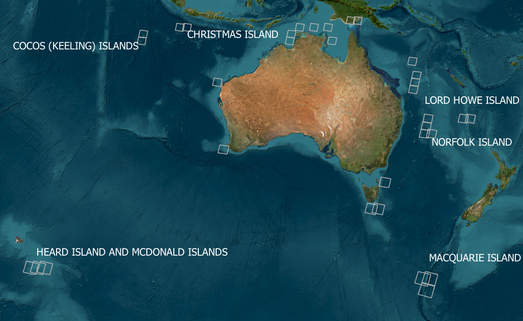
The locations of the Landsat scenes.
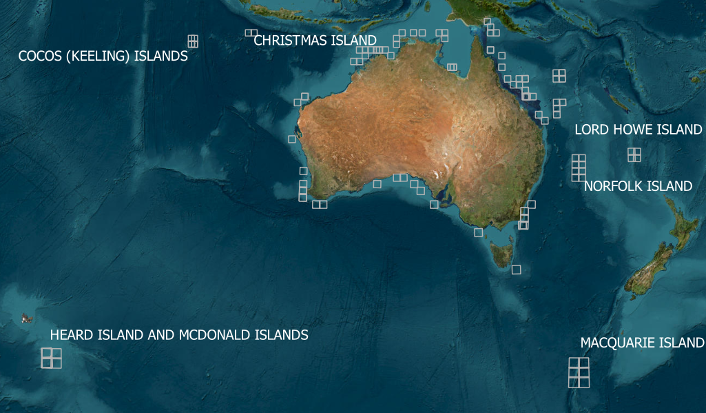
The locations of the Sentinel-2 tiles.
Region |
Scenes & Tiles |
|---|---|
Heard Island and MacDonald Islands |
134-097, 135-097, 136-097, 43FDA, 43FDB, 43FCB, 43FCA |
Lord Howe Island |
084-082, 085-082, 59JKJ, 58JGP, 59JKH, 58JGN |
MacQuarie Island |
080-098, 079-098, 079-099, 57FWU, 57FWV, 57FVV, 57FWA, 57FVA, 57FVU |
Norfolk Island |
079-080, 080-080, 57JWF, 57JVF, 57HVE, 57HWE |
Christmas Island |
122-067, 123-067, 48LWP, 48LXP |
Cocos (Keeling) Islands |
128-068, 128-069, 47LKG, 47LKH, 46LHN, 46LHM |
Talbot Islands, Dauan Island, Saibai Island, and Boigu Island |
099-066 |
Daru, Western Province Papua New Guinea, and Northern Warrior Reefs |
098-066, 54LZR |
Elizabeth Reef |
085-081, 57JVG, 57JWG |
Middleton Reef |
085-080, 57JVH, 57JWH |
Frederick Reef, Queensland |
088-075, 56KQB, 57KTS, 56KQA |
Coral Sea |
089-072, 088-074, 088-076, 54LZL, 55KEA, 55KFV, 55KGA, 55KGV, 55KHA, 55KHT, 55KHU, 55LBF, 55LBJ, 55LBK, 55LCJ, 55LDC, 55LDE, 56KKC, 55KKD, 56KKF, 56KLC, 56KMV, 56KNU, 56KQA, 56KQB, 56KQF, 56KQG, 56KQV, 56KRB, 56KRF, 56KRG, 57KTA, 57KTB, 57KTS, 57KTS |
Gulf of Carpentaria |
101-069, 53LRC, 54LTH |
Arafura Sea |
102-067, 104-067, 106-067, 107-068, 107-069, 52LEM, 52LEN, 52LFP, 52LHP, 53LLJ, 53LPJ, 53LQH, 53LQJ |
Timor Sea |
51LVD, 51LWD, 51LWF, 51LXE, 51LXF, 51LYF, 51LZF, 52LBL, 52LCL, 52LDK |
Indian Ocean |
116-075, 49HGB, 49HGC, 49JFL, 49KGS, 49KHT, 50HKG, 50HKH, 50HKJ, 50HMF, 50HNF, 50JKL, 50KKC |
Great Australian Bight |
52HBI, 52HEK, 52HFK, 53HKD, 53HLC, 53HNA |
Augusta, Western Australia |
113-084 |
Tasman Sea |
089-088, 089-091, 090-091, 55GFM |
Bass Strait |
54HXB |
Query and metadata
The quality of ancillary and level 1 inputs used in ARD generation in offshore locations differs in comparison to inputs used on continental Australia. Quality information for ancillary inputs is found in the proc-info (processing information) YAML metadata file within the dataset. The tier list is USER, FALLBACK, and DEFINITIVE, with the latter being the highest level of quality. Unfortunately, this information is not available to users via the datacube, so we have added an additional metadata tag to delineate data delivered in this update: final_ancillaries = "nonstandard"
dc.find_datasets(product="ga_ls8c_ard_3", limit=10, final_ancillaries="nonstandard")
Geometric quality issues
ARD is a Surface Reflectance product that is derived from USGS or ESA Level 1 products. The Level 1 product is geometrically corrected such that the product is ‘ortho-rectified’ which results in enabling acquisitions from different dates to be spatially overlaid for assessment through time. The ARD product provides a comprehensive quality assurance of geometric correction known as GQA, which is found in the dataset and processing information metadata.
This update features the addition of Landsat scenes and Sentinel 2 tiles over islands and reefs. Some of these islands, such as Christmas Island or islands south of Papua New Guinea, are at extremely high or low latitudes and are affected by persistent cloud. This presents challenges when correlating the reference image against source images to ortho-rectify or provide statistical geometric comparisons.
The following map represents the density of USGS Level 1 L1TP scenes over the extended area. These scenes are used as input for Landsat ARD generation and represent higher geometric accuracy as ground control points and a digital elevation model is incorporated into ortho-processing. Locations with L1TP Level 1 inputs are scenes that contain islands, land or reef features that can be used as a control. Locations entirely over shallow Ocean have been added for bathymetric purposes and have low geometric accuracy.
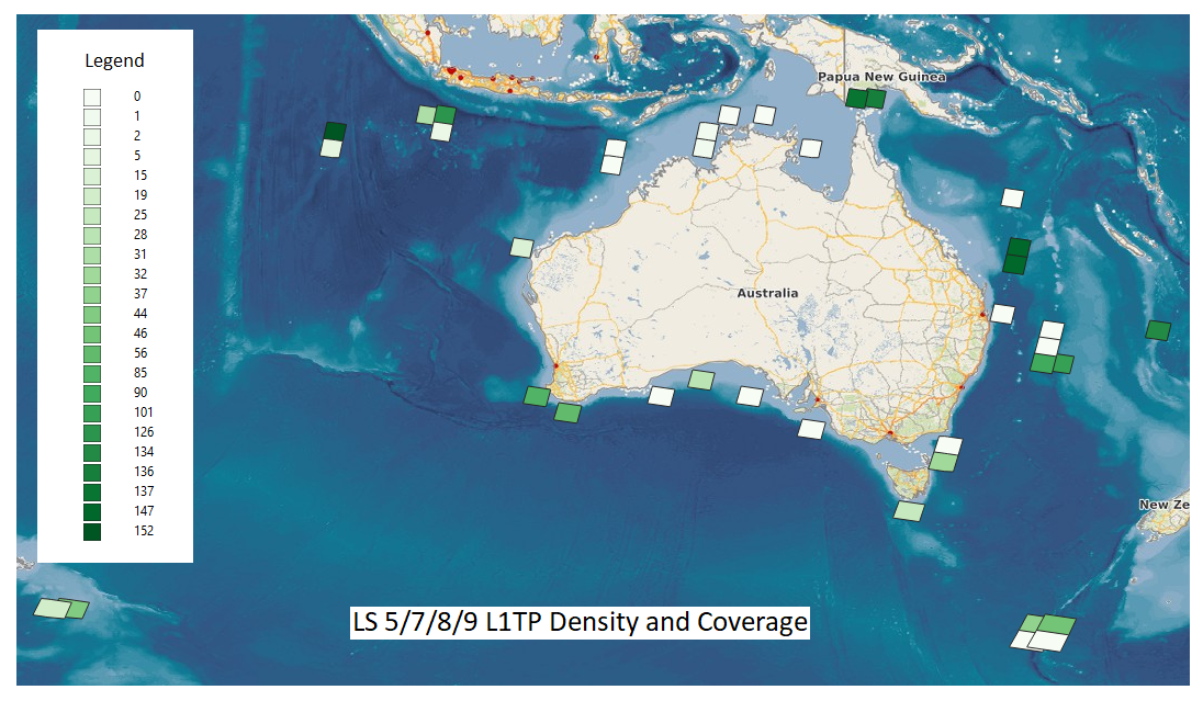
Landsat 5, 7, 8, and 9 L1TP Density and Coverage
Elevation model
Surface reflectance data processed over the Australian mainland uses an SRTM elevation model with an effective spatial resolution of 45 metres. The offshore territories have been processed using the Copernicus DEM which has an effective resolution of 30 metres. Additionally both the Copernicus DEM and mainland SRTM model have been improved to remove striping, fill voids and smooth speckle.
The higher resolution results in false terrain correction in low relief areas. Features such as clusters of trees, large stand alone trees, tall buildings or rocks can cause terrain correction artefacts, including false shadow masks.
Bidirectional reflectance distribution function (BRDF)
BRDF is a solar illumination correction that adjusts reflectance intensity in differing amounts in differing directions. The light that comes from the Sun reflects off the Earth and is received by the sensor is adjusted based on the viewing or solar angle geometries of MODIS data.
Sometimes over offshore locations, we have found BRDF values to be unphysical. We have implemented a BRDF solution over the offshore locations, which masks out data from solar illumination correction where \(\frac{Fvol}{Fisor} > 1\) or \(\frac{Fgeo}{Fiso} > 1\). This ensures that we do not violate the theoretical definition of these parameters, meaning the values are realistic.
Water vapor
There is no ancillary source dataset difference between mainland and offshore locations.
Aerosol
A constant value of 0.06 Aerosol Optical Depth (AOD) is used as ancillary input as we do not have aerosol data for these extended locations. This constant value is based on the assumption that the average AOD data in Australian continental is around 0.05, but since islands are surrounded by the sea and impacted by salt water particles, it assumes the slightly higher value of 0.06.
Ozone
The Ozone constant value for ancillary input is set to 0.275 ATM-CM. In the extended offshore locations, Ozone is typically around 0.25 to 0.3. Ozone does not impact radiometric values in bands (wavelengths) by a significant amount.