Analysis Ready Data: Open Data Cube
The Open Data Cube (ODC) is an open-source solution for accessing, managing, and analysing large quantities of Geographic Information System (GIS) data — namely Earth observation data. It is a global initiative to increase the value and use of satellite data by providing users with access to free and open data management technologies and analysis platforms.
At its core, ODC is a set of Python libraries and a PostgreSQL database that allows you to work with geospatial raster data.
This article will show you how to query the DEA Open Data Cube.
Example 1 – Analysis Ready Data product
The following Python code is an example Open Data Cube query to return the following properties:
green, red and near-infrared measurements from the GA Landsat 5 TM NBAR Collection 3 and GA Landsat 5 TM NBART Collection 3 products
Fmask layer from the GA Landsat 5 TM OA Collection 3 product
Region of Interest (ROI): Longitude 146.54 → 147.94; latitude -19.42 → -21.03
Acquisition time of interest: 1990-07-20
All products are nestled under the parent product GA Landsat 5 TM Analysis Ready Data Collection 3 (Open Data Cube product ID: ga_ls5t_ard_3).
data = dc.load(
    product='ga_ls5t_ard_3',
    measurements=['nbart_swir_2', 'nbart_blue', 'nbart_green', 'nbart_red', 'nbart_nir', 'nbar_green', 'nbar_red', 'nbar_nir', 'oa_fmask', 'nbart-contiguity'],
    lon=(146.54, 147.94),
    lat=(-19.42, -21.03),
    time=('1990-07-20', '1990-07-21'),
    output_crs='EPSG:3577',
    resolution=(-30, 30)
)
The Data Cube query produces the following images:
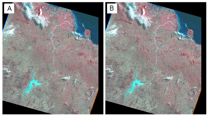
Image A is the false colour composite [‘nbart_nir’, ‘nbart_red’, ‘nbart_green’] displayed as [Red, Green, Blue] from the **GA Landsat 5 TM NBART Collection 3 **product.
Image B is the false colour composite [‘nbart_nir’, ‘nbart_red’, ‘nbart_green’] displayed as [Red, Green, Blue] from the **GA Landsat 5 TM NBAR Collection 3 **product.
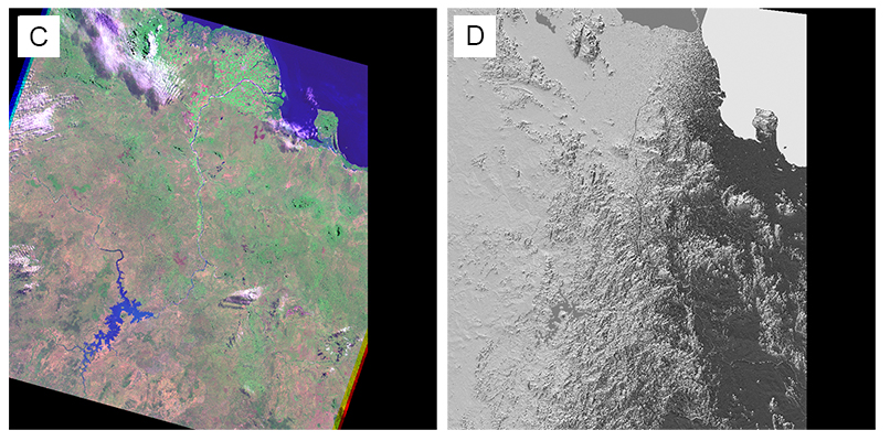
Image C is another GA Landsat 5 TM NBART Collection 3 false colour composite, but uses a different combination of spectral bands [‘nbart_swir_2’, ‘nbart_nir’, ‘nbart_blue’] displayed as [Red, Green, Blue].
Image D is the relative slope dataset.
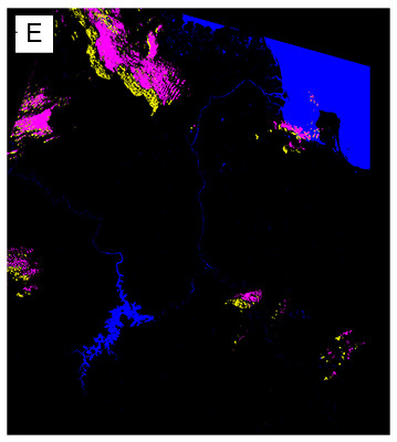
Image E is the Fmask classification result from the GA Landsat 5 TM NBART Collection 3 product. The colours for the Fmask classification are displayed as:
Black = clear
Magenta = cloud
Yellow = cloud shadow
Cyan = snow
Dark blue = water
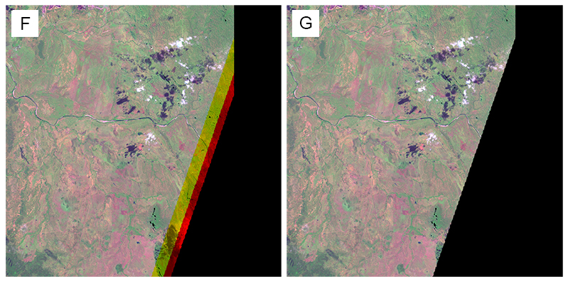
Images F and G represent the GA Landsat 5TM NBART Collection 3 false colour composite, with pre- and post-application of the contiguity mask, respectively.
Note that the different spectral bands have different data extents at the edges of the scene (denoted by yellow and red strips). When using the contiguity mask, the data edges have been cut back to where data coexists for all spectral bands.
Example 2 – NBAR product
The following Python code is an example Open Data Cube query to return the following properties:
green, red and near-infrared measurements from the GA Landsat 5 TM NBAR Collection 3 product
Fmask layer from the GA Landsat 5 TM OA Collection 3 product
Region of Interest (ROI): Longitude 146.54 → 147.94; latitude -19.42 → -21.03
Acquisition time of interest: 1990-07-20
Both products are nestled under the parent product GA Landsat 5 TM Analysis Ready Data Collection 3 (Open Data Cube product ID: ga_ls5t_ard_3).
data = dc.load(
    product='ga_ls5t_ard_3',
    measurements=['nbar_green', 'nbar_red', 'nbar_nir', 'oa_fmask'],
    lon=(146.54, 147.94),
    lat=(-19.42, -21.03),
    time=('1990-07-20', '1990-07-21'),
    output_crs='EPSG:3577',
    resolution=(-30, 30)
)
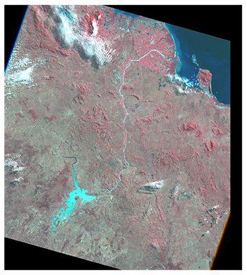
The Data Cube query produces the following image, which is the false colour composite [‘nbar_nir’, ‘nbar_red’, ‘nbar_green’] displayed as [Red, Green, Blue].
Example 3 – NBART product
The following Python code is an example Open Data Cube query to return the following properties:
green, red and near-infrared measurements from the GA Landsat 5 TM NBART Collection 3 product
Fmask layer from the GA Landsat 5 TM OA Collection 3 product
Region of Interest (ROI): Longitude 146.54 → 147.94; latitude -19.42 → -21.03
Acquisition time of interest: 1990-07-20
Both products are nestled under the parent product GA Landsat 5 TM Analysis Ready Data Collection 3 (Open Data Cube product ID: ga_ls5t_ard_3).
data = dc.load(
    product='ga_ls5t_ard_3',
    measurements=['nbart_green', 'nbart_red', 'nbart_nir', 'oa_fmask'],
    lon=(146.54, 147.94),
    lat=(-19.42, -21.03),
    time=('1990-07-20', '1990-07-21'),
    output_crs='EPSG:3577',
    resolution=(-30, 30)
)
The Data Cube query produces the following images:
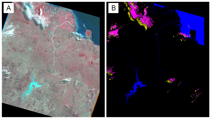
Image A is the false colour composite [‘nbart_nir’, ‘nbart_red’, ‘nbart_green’] displayed as [Red, Green, Blue].
Image B is the Fmask classification result. The colours for the Fmask classification are displayed as:
Black = clear
Magenta = cloud
Yellow = cloud shadow
Cyan = snow
Dark blue = water
Product file naming convention
DEA product files follow a specific naming convention on Open Data Cube:
{product}-{minor version}-{patch version}{spatial location}{acquisition date}{label}{description id}.{extension}
The fields are defined as follows:
| {product} | Open Data Cube product ID (e.g. ga_ls5t_nbar_3) |
| {minor version} | A single integer |
| {patch version} | A single integer |
| {spatial location} | The combination of 'path' and 'row' locations. Both 'path' and 'low' are zero-padded strings of length 3, which make a 6-integer number when combined (e.g. 092 and 084 make 092084) |
| {acquisition date} | Has the form yyyy-mm-dd |
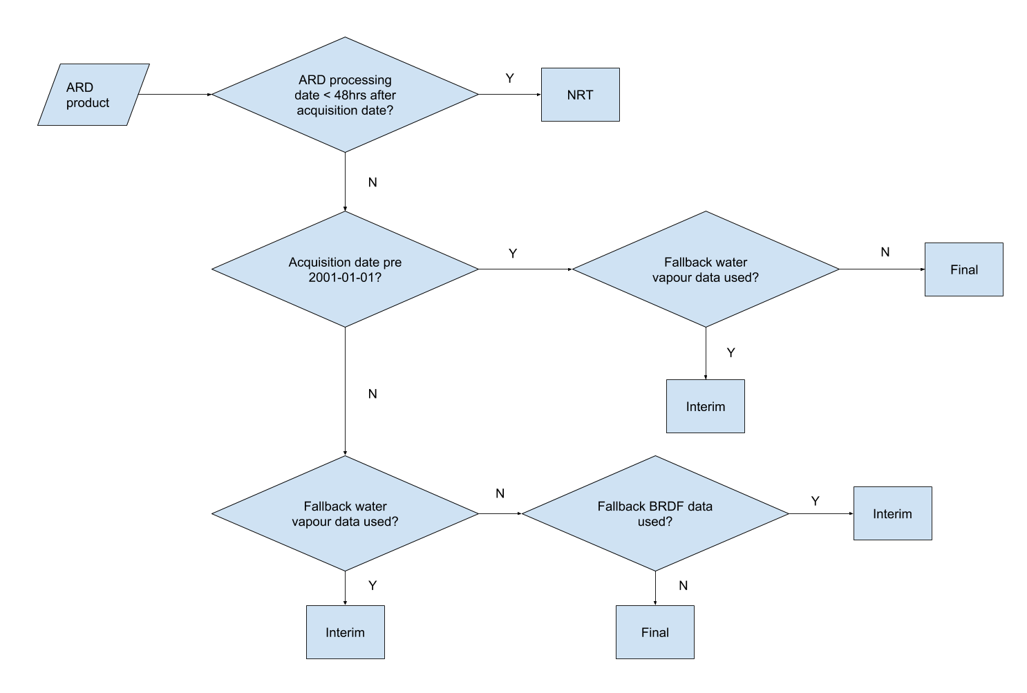
| {label} |
Can be one of the following: nrt
interim
final
(See flow process diagram below) |
| {description ID} | e.g. band01, band02, band03, thumbnail, fmask, satellite-view |
| {extension} | e.g. tif, jpg |
Flow process for determining the label (nrt, interim or final)
Example files
Below is a list of representative samples which demonstrate the application of the naming conventions. The folders follow the product ID, path, row, year, month, day format.
Example 1 - GA Landsat 5 TM Analysis Ready Data Collection 3
└── ga_ls5t_ard_3              <== Product ID
     └── 092                   <== Path
         └── 084               <== Row
             └── 2009          <== Year
                 └── 12        <== Month
                     └── 17    <== Day
                         ├── ga_ls5t_ard_3-0-0_092084_2009-12-17_final.odc-metadata.yaml
                         ├── ga_ls5t_ard_3-0-0_092084_2009-12-17_final.proc-info.yaml
                         ├── ga_ls5t_ard_3-0-0_092084_2009-12-17_final.sha1
                         ├── ga_ls5t_nbar_3-0-0_092084_2009-12-17_final_band01.tif
                         ├── ga_ls5t_nbar_3-0-0_092084_2009-12-17_final_band02.tif
                         ├── ga_ls5t_nbar_3-0-0_092084_2009-12-17_final_band03.tif
                         ├── ga_ls5t_nbar_3-0-0_092084_2009-12-17_final_band04.tif
                         ├── ga_ls5t_nbar_3-0-0_092084_2009-12-17_final_band05.tif
                         ├── ga_ls5t_nbar_3-0-0_092084_2009-12-17_final_band07.tif
                         ├── ga_ls5t_nbar_3-0-0_092084_2009-12-17_final_thumbnail.jpg
                         ├── ga_ls5t_nbart_3-0-0_092084_2009-12-17_final_band01.tif
                         ├── ga_ls5t_nbart_3-0-0_092084_2009-12-17_final_band02.tif
                         ├── ga_ls5t_nbart_3-0-0_092084_2009-12-17_final_band03.tif
                         ├── ga_ls5t_nbart_3-0-0_092084_2009-12-17_final_band04.tif
                         ├── ga_ls5t_nbart_3-0-0_092084_2009-12-17_final_band05.tif
                         ├── ga_ls5t_nbart_3-0-0_092084_2009-12-17_final_band07.tif
                         ├── ga_ls5t_nbart_3-0-0_092084_2009-12-17_final_thumbnail.jpg
                         ├── ga_ls5t_oa_3-0-0_092084_2009-12-17_final_azimuthal-exiting.tif
                         ├── ga_ls5t_oa_3-0-0_092084_2009-12-17_final_azimuthal-incident.tif
                         ├── ga_ls5t_oa_3-0-0_092084_2009-12-17_final_combined-terrain-shadow.tif
                         ├── ga_ls5t_oa_3-0-0_092084_2009-12-17_final_exiting-angle.tif
                         ├── ga_ls5t_oa_3-0-0_092084_2009-12-17_final_fmask.tif
                         ├── ga_ls5t_oa_3-0-0_092084_2009-12-17_final_incident-angle.tif
                         ├── ga_ls5t_oa_3-0-0_092084_2009-12-17_final_nbar-contiguity.tif
                         ├── ga_ls5t_oa_3-0-0_092084_2009-12-17_final_nbart-contiguity.tif
                         ├── ga_ls5t_oa_3-0-0_092084_2009-12-17_final_relative-azimuth.tif
                         ├── ga_ls5t_oa_3-0-0_092084_2009-12-17_final_relative-slope.tif
                         ├── ga_ls5t_oa_3-0-0_092084_2009-12-17_final_satellite-azimuth.tif
                         ├── ga_ls5t_oa_3-0-0_092084_2009-12-17_final_satellite-view.tif
                         ├── ga_ls5t_oa_3-0-0_092084_2009-12-17_final_solar-azimuth.tif
                         ├── ga_ls5t_oa_3-0-0_092084_2009-12-17_final_solar-zenith.tif
                         └── ga_ls5t_oa_3-0-0_092084_2009-12-17_final_time-delta.tif
Example 2 - GA Landsat 7 ETM+ Analysis Ready Data Collection 3
└── ga_ls7e_ard_3              <== Product ID
     └── 092                   <== Path
         └── 084               <== Row
             └── 2016          <== Year
                 └── 06        <== Month
                     └── 04    <== Day
                         ├── ga_ls7e_ard_3-0-0_092084_2016-06-04_final.odc-metadata.yaml
                         ├── ga_ls7e_ard_3-0-0_092084_2016-06-04_final.proc-info.yaml
                         ├── ga_ls7e_ard_3-0-0_092084_2016-06-04_final.sha1
                         ├── ga_ls7e_nbar_3-0-0_092084_2016-06-04_final_band01.tif
                         ├── ga_ls7e_nbar_3-0-0_092084_2016-06-04_final_band02.tif
                         ├── ga_ls7e_nbar_3-0-0_092084_2016-06-04_final_band03.tif
                         ├── ga_ls7e_nbar_3-0-0_092084_2016-06-04_final_band04.tif
                         ├── ga_ls7e_nbar_3-0-0_092084_2016-06-04_final_band05.tif
                         ├── ga_ls7e_nbar_3-0-0_092084_2016-06-04_final_band07.tif
                         ├── ga_ls7e_nbar_3-0-0_092084_2016-06-04_final_band08.tif
                         ├── ga_ls7e_nbar_3-0-0_092084_2016-06-04_final_thumbnail.jpg
                         ├── ga_ls7e_nbart_3-0-0_092084_2016-06-04_final_band01.tif
                         ├── ga_ls7e_nbart_3-0-0_092084_2016-06-04_final_band02.tif
                         ├── ga_ls7e_nbart_3-0-0_092084_2016-06-04_final_band03.tif
                         ├── ga_ls7e_nbart_3-0-0_092084_2016-06-04_final_band04.tif
                         ├── ga_ls7e_nbart_3-0-0_092084_2016-06-04_final_band05.tif
                         ├── ga_ls7e_nbart_3-0-0_092084_2016-06-04_final_band07.tif
                         ├── ga_ls7e_nbart_3-0-0_092084_2016-06-04_final_band08.tif
                         ├── ga_ls7e_nbart_3-0-0_092084_2016-06-04_final_thumbnail.jpg
                         ├── ga_ls7e_oa_3-0-0_092084_2016-06-04_final_azimuthal-exiting.tif
                         ├── ga_ls7e_oa_3-0-0_092084_2016-06-04_final_azimuthal-incident.tif
                         ├── ga_ls7e_oa_3-0-0_092084_2016-06-04_final_combined-terrain-shadow.tif
                         ├── ga_ls7e_oa_3-0-0_092084_2016-06-04_final_exiting-angle.tif
                         ├── ga_ls7e_oa_3-0-0_092084_2016-06-04_final_fmask.tif
                         ├── ga_ls7e_oa_3-0-0_092084_2016-06-04_final_incident-angle.tif
                         ├── ga_ls7e_oa_3-0-0_092084_2016-06-04_final_nbar-contiguity.tif
                         ├── ga_ls7e_oa_3-0-0_092084_2016-06-04_final_nbart-contiguity.tif
                         ├── ga_ls7e_oa_3-0-0_092084_2016-06-04_final_relative-azimuth.tif
                         ├── ga_ls7e_oa_3-0-0_092084_2016-06-04_final_relative-slope.tif
                         ├── ga_ls7e_oa_3-0-0_092084_2016-06-04_final_satellite-azimuth.tif
                         ├── ga_ls7e_oa_3-0-0_092084_2016-06-04_final_satellite-view.tif
                         ├── ga_ls7e_oa_3-0-0_092084_2016-06-04_final_solar-azimuth.tif
                         ├── ga_ls7e_oa_3-0-0_092084_2016-06-04_final_solar-zenith.tif
                         └── ga_ls7e_oa_3-0-0_092084_2016-06-04_final_time-delta.tif
Example 3 - GA Landsat 8 OLI/TIRS Analysis Ready Data Collection 3
└── ga_ls8c_ard_3              <== Product ID
     └── 092                   <== Path
         └── 084               <== Row
             └── 2016          <== Year
                 └── 06        <== Month
                     └── 28    <== Day
                         ├── ga_ls8c_ard_3-0-0_092084_2016-06-28_final.odc-metadata.yaml
                         ├── ga_ls8c_ard_3-0-0_092084_2016-06-28_final.proc-info.yaml
                         ├── ga_ls8c_ard_3-0-0_092084_2016-06-28_final.sha1
                         ├── ga_ls8c_nbar_3-0-0_092084_2016-06-28_final_band01.tif
                         ├── ga_ls8c_nbar_3-0-0_092084_2016-06-28_final_band02.tif
                         ├── ga_ls8c_nbar_3-0-0_092084_2016-06-28_final_band03.tif
                         ├── ga_ls8c_nbar_3-0-0_092084_2016-06-28_final_band04.tif
                         ├── ga_ls8c_nbar_3-0-0_092084_2016-06-28_final_band05.tif
                         ├── ga_ls8c_nbar_3-0-0_092084_2016-06-28_final_band06.tif
                         ├── ga_ls8c_nbar_3-0-0_092084_2016-06-28_final_band07.tif
                         ├── ga_ls8c_nbar_3-0-0_092084_2016-06-28_final_band08.tif
                         ├── ga_ls8c_nbar_3-0-0_092084_2016-06-28_final_thumbnail.jpg
                         ├── ga_ls8c_nbart_3-0-0_092084_2016-06-28_final_band01.tif
                         ├── ga_ls8c_nbart_3-0-0_092084_2016-06-28_final_band02.tif
                         ├── ga_ls8c_nbart_3-0-0_092084_2016-06-28_final_band03.tif
                         ├── ga_ls8c_nbart_3-0-0_092084_2016-06-28_final_band04.tif
                         ├── ga_ls8c_nbart_3-0-0_092084_2016-06-28_final_band05.tif
                         ├── ga_ls8c_nbart_3-0-0_092084_2016-06-28_final_band06.tif
                         ├── ga_ls8c_nbart_3-0-0_092084_2016-06-28_final_band07.tif
                         ├── ga_ls8c_nbart_3-0-0_092084_2016-06-28_final_band08.tif
                         ├── ga_ls8c_nbart_3-0-0_092084_2016-06-28_final_thumbnail.jpg
                         ├── ga_ls8c_oa_3-0-0_092084_2016-06-28_final_azimuthal-exiting.tif
                         ├── ga_ls8c_oa_3-0-0_092084_2016-06-28_final_azimuthal-incident.tif
                         ├── ga_ls8c_oa_3-0-0_092084_2016-06-28_final_combined-terrain-shadow.tif
                         ├── ga_ls8c_oa_3-0-0_092084_2016-06-28_final_exiting-angle.tif
                         ├── ga_ls8c_oa_3-0-0_092084_2016-06-28_final_fmask.tif
                         ├── ga_ls8c_oa_3-0-0_092084_2016-06-28_final_incident-angle.tif
                         ├── ga_ls8c_oa_3-0-0_092084_2016-06-28_final_nbar-contiguity.tif
                         ├── ga_ls8c_oa_3-0-0_092084_2016-06-28_final_nbart-contiguity.tif
                         ├── ga_ls8c_oa_3-0-0_092084_2016-06-28_final_relative-azimuth.tif
                         ├── ga_ls8c_oa_3-0-0_092084_2016-06-28_final_relative-slope.tif
                         ├── ga_ls8c_oa_3-0-0_092084_2016-06-28_final_satellite-azimuth.tif
                         ├── ga_ls8c_oa_3-0-0_092084_2016-06-28_final_satellite-view.tif
                         ├── ga_ls8c_oa_3-0-0_092084_2016-06-28_final_solar-azimuth.tif
                         ├── ga_ls8c_oa_3-0-0_092084_2016-06-28_final_solar-zenith.tif
                         └── ga_ls8c_oa_3-0-0_092084_2016-06-28_final_time-delta.tif